Geolocate

Nanda Devi topographic map

Interactive map

Click on the map to display elevation.

About this map

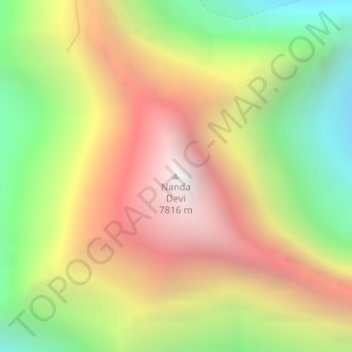
Name: Nanda Devi topographic map, elevation, terrain.

Location: Nanda Devi, Joshimath Tehsil, Chamoli District, Uttarakhand, India (30.37603 79.97007 30.37613 79.97017)

Average elevation: 6,567 m

Minimum elevation: 5,371 m

Maximum elevation: 7,782 m

Other topographic maps

Click on a map to view its topography, its elevation and its terrain.

Valley of Flowers National Park

India > Uttarakhand > Joshimath Tehsil

Valley of Flowers National Park, Joshimath Tehsil, Chamoli District, Uttarakhand, India

Average elevation: 4,606 m

Dadon

India > Uttarakhand > Joshimath Tehsil > Joshimath

Dadon, Joshimath, Joshimath Tehsil, Chamoli district, Uttarakhand, India

Average elevation: 2,107 m

Pangarchulla

India > Uttarakhand > Joshimath Tehsil

Pangarchulla, Joshimath Tehsil, Chamoli District, Uttarakhand, 246483, India

Average elevation: 4,061 m

Joshimath

India > Uttarakhand > Joshimath Tehsil

Joshimath, Joshimath Tehsil, Chamoli district, Uttarakhand, India

Average elevation: 2,272 m

Pinola

India > Uttarakhand > Joshimath Tehsil > Govindghat > Pinola

Pinola, Govindghat, Joshimath Tehsil, Chamoli district, Uttarakhand, India

Average elevation: 2,454 m

Hemkund

India > Uttarakhand > Joshimath Tehsil

Hemkund, Joshimath Tehsil, Chamoli district, Uttarakhand, India

Average elevation: 4,367 m

Badrinath

India > Uttarakhand > Joshimath Tehsil

Badrinath, Joshimath Tehsil, Chamoli District, Uttarakhand, India

Average elevation: 4,052 m