
Blonay topographic map
Interactive map
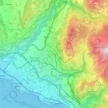
Click on the map to display elevation.
About this map
Name: Blonay topographic map, elevation, terrain.
Average elevation: 885 m
Minimum elevation: 367 m
Maximum elevation: 1,733 m
Blonay overlooks Lake Geneva, with the hill 'Les Pléiades' behind the town. The municipality stretches from an elevation of about 500 to 1,400 m (1,600 to 4,600 ft). It consists of the village of Blonay with the sections of Tercier and Cojonnex and a number of hamlets including Les Chevalleyres.
Other topographic maps
Click on a map to view its topography, its elevation and its terrain.
Veveyse
Switzerland > Vaud > District de la Riviera-Pays-d’Enhaut > Blonay - Saint-Légier
Veveyse, Blonay - Saint-Légier, District de la Riviera-Pays-d’Enhaut, Vaud, 1809, Switzerland
Average elevation: 742 m