
Cumilla topographic map
Interactive map
Click on the map to display elevation.
About this map
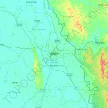
Name: Cumilla topographic map, elevation, terrain.
Average elevation: 16 m
Minimum elevation: 4 m
Maximum elevation: 88 m
Other topographic maps
Click on a map to view its topography, its elevation and its terrain.
Bojoypur
Bangladesh > Chattogram Division > Cumilla Adarsha Sadar Upazila
Bojoypur, Cumilla Adarsha Sadar Upazila, Cumilla District, Chattogram Division, Bangladesh
Average elevation: 11 m