
Mekong River topographic map
Interactive map
Click on the map to display elevation.
About this map
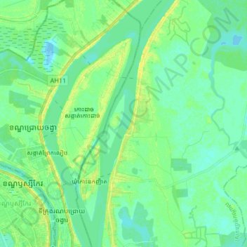
Name: Mekong River topographic map, elevation, terrain.
Location: Mekong River, Koki commune, Kandal, 12110, Cambodia (11.59536 104.94213 11.72748 104.97625)
Average elevation: 8 m
Minimum elevation: 2 m
Maximum elevation: 19 m
Other topographic maps
Click on a map to view its topography, its elevation and its terrain.
Mekong River
Cambodia > Kandal > Khsach Kandal District
Mekong River, Khsach Kandal District, Kandal, Cambodia
Average elevation: 8 m
Krong Ta Khmau
Cambodia > Kandal > Krong Ta Khmau
Krong Ta Khmau, Kandal, Cambodia
Average elevation: 8 m
Ruessei Chrouy
Cambodia > Kandal > Mukh Kampul District
Ruessei Chrouy, Mukh Kampul District, Kandal, Cambodia
Average elevation: 10 m