
Mississippi River topographic map
Interactive map
Click on the map to display elevation.
About this map
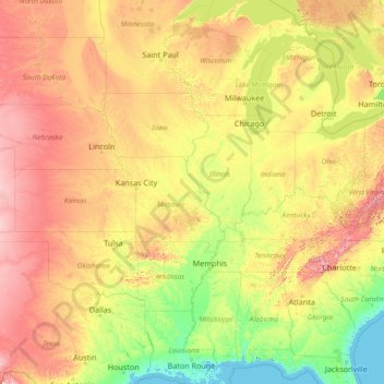
Name: Mississippi River topographic map, elevation, terrain.
Location: Mississippi River, United States (29.15784 -95.24694 47.49749 -89.09884)
Average elevation: 344 m
Minimum elevation: -3 m
Maximum elevation: 1,927 m
The uppermost lock and dam on the Upper Mississippi River is the Upper St. Anthony Falls Lock and Dam in Minneapolis. Above the dam, the river's elevation is 799 feet (244 m). Below the dam, the river's elevation is 750 feet (230 m). This 49-foot (15 m) drop is the largest of all the Mississippi River locks and dams. The origin of the dramatic drop is a waterfall preserved adjacent to the lock under an apron of concrete. Saint Anthony Falls is the only true waterfall on the entire Mississippi River. The water elevation continues to drop steeply as it passes through the gorge carved by the waterfall.
Other topographic maps
Click on a map to view its topography, its elevation and its terrain.
Los Angeles
Los Angeles, Los Angeles County, California, United States
Average elevation: 241 m
Brooklyn
United States > New York > New York
Brooklyn, Kings County, New York, United States
Average elevation: 9 m
Spokane
United States > Washington > Spokane County
Spokane, Spokane County, Washington, United States
Average elevation: 655 m
Jacksonville
United States > Florida > Duval County
Jacksonville, Duval County, Florida, United States
Average elevation: 10 m
Sonoma County
Sonoma County, California, United States
Average elevation: 210 m
Hillsborough County
Hillsborough County, Florida, United States
Average elevation: 20 m
Madison
United States > Wisconsin > Dane County
Madison, Dane County, Wisconsin, United States
Average elevation: 284 m
Middle East
United States > Maryland > Baltimore
Middle East, Baltimore, Maryland, United States
Average elevation: 29 m
Everglades National Park
United States > Florida > Monroe County
Everglades National Park, Monroe County, Florida, United States
Average elevation: 2 m
New Orleans
United States > Louisiana > Orleans Parish
New Orleans, Orleans Parish, Louisiana, United States
Average elevation: 1 m
Queens County
United States > New York > New York
Queens County, New York, United States
Average elevation: 11 m
Castle Rock
United States > Colorado > Douglas County
Castle Rock, Douglas County, Colorado, United States
Average elevation: 1,952 m
Onslow County
United States > North Carolina
Onslow County, North Carolina, United States
Average elevation: 11 m
Knoxville
United States > Tennessee > Knox County
Knoxville, Knox County, East Tennessee, Tennessee, United States
Average elevation: 307 m
Corpus Christi
United States > Texas > Nueces County
Corpus Christi, Nueces County, Texas, United States
Average elevation: 8 m
Sacramento
United States > California > Sacramento County
Sacramento, Sacramento County, California, United States
Average elevation: 10 m