
Xanthi topographic map
Interactive map
Click on the map to display elevation.
About this map
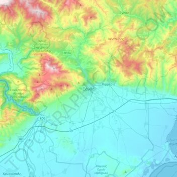
Name: Xanthi topographic map, elevation, terrain.
Average elevation: 311 m
Minimum elevation: -5 m
Maximum elevation: 1,408 m
Other topographic maps
Click on a map to view its topography, its elevation and its terrain.
Συδινή
Greece > Macedonia and Thrace > Xanthi Regional Unit
Συδινή, Abdera Municipality, Xanthi Regional Unit, Eastern Macedonia and Thrace, Macedonia and Thrace, 670 64, Greece
Average elevation: 13 m
Κόσυνθος
Greece > Macedonia and Thrace > Xanthi Regional Unit
Κόσυνθος, Xanthi Regional Unit, Eastern Macedonia and Thrace, Macedonia and Thrace, 67132, Greece
Average elevation: 423 m