
Make a donation
Gear up for your next adventure:
As an Amazon Associate, this site earns from qualifying purchases at no extra cost to you.
Gran Canaria topographic map
Click on the map to display elevation.
Make a donation
Gear up for your next adventure:
As an Amazon Associate, this site earns from qualifying purchases at no extra cost to you.
Gran Canaria
Gran Canaria is located in the Atlantic Ocean in a region known as Macaronesia about 150 kilometres (93 mi) off the northwestern coast of Africa and about 1,350 km (840 mi) from Europe. With an area of 1,560 km2 (602 sq. mi) and an altitude of 1,956 m (6,417 ft) at Morro de la Agujereada, Gran Canaria is the third largest island of the archipelago in both area and altitude. Gran Canaria is also the third most populated island in Spain.
Make a donation
Gear up for your next adventure:
As an Amazon Associate, this site earns from qualifying purchases at no extra cost to you.
About this map
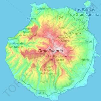
Name: Gran Canaria topographic map, elevation, terrain.
Location: Gran Canaria, Canary Islands, Spain (27.73458 -15.83465 28.18143 -15.35828)
Average elevation: 335 m
Minimum elevation: -1 m
Maximum elevation: 1,933 m
Make a donation
Gear up for your next adventure:
As an Amazon Associate, this site earns from qualifying purchases at no extra cost to you.
Other topographic maps
Click on a map to view its topography, its elevation and its terrain.
Parque de la Puerta de Tierra
Spain > Canary Islands > San Juan del Reparo (La Culata) > San Pedro de Daute
Average elevation: 182 m
Masca
Spain > Canary Islands > Buenavista del Norte
Masca is a small mountain village on the island of Tenerife. It was originally a Guanche settlement before the Spanish conquest in 1496. The village is now home to around 90 inhabitants. The village lies at an altitude of 650 m in the Macizo de Teno mountains, which extend up to the northwesternmost point of…
Average elevation: 769 m
Make a donation
Gear up for your next adventure:
As an Amazon Associate, this site earns from qualifying purchases at no extra cost to you.
Make a donation
Gear up for your next adventure:
As an Amazon Associate, this site earns from qualifying purchases at no extra cost to you.
Make a donation
Gear up for your next adventure:
As an Amazon Associate, this site earns from qualifying purchases at no extra cost to you.
Make a donation
Gear up for your next adventure:
As an Amazon Associate, this site earns from qualifying purchases at no extra cost to you.
Make a donation
Gear up for your next adventure:
As an Amazon Associate, this site earns from qualifying purchases at no extra cost to you.
Make a donation
Gear up for your next adventure:
As an Amazon Associate, this site earns from qualifying purchases at no extra cost to you.
Make a donation
Gear up for your next adventure:
As an Amazon Associate, this site earns from qualifying purchases at no extra cost to you.
Make a donation
Gear up for your next adventure:
As an Amazon Associate, this site earns from qualifying purchases at no extra cost to you.