
Bas-Rhin topographic map
Interactive map
Click on the map to display elevation.
About this map
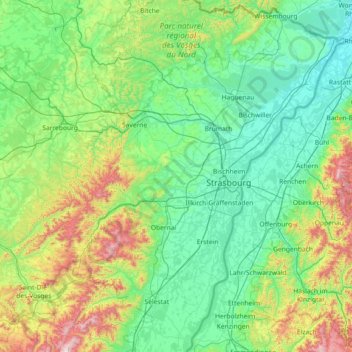
Name: Bas-Rhin topographic map, elevation, terrain.
Location: Bas-Rhin, Grand Est, Metropolitan France, France (48.12043 6.94063 49.07779 8.23285)
Average elevation: 315 m
Minimum elevation: 104 m
Maximum elevation: 1,274 m
Bas-Rhin (French pronunciation: [bɑ.ʁɛ̃]; Alsatian: Unterelsàss, ‘s Unterlànd or ‘s Ingerlànd; traditional German: Niederrhein; English: Lower Rhine) is a department in Alsace which is a part of the Grand Est super-region of France. The name means 'Lower Rhine', referring to its lower altitude among the two French Rhine departments: it is downstream of the Haut-Rhin (Upper Rhine) department. Note that both belong to the European Upper Rhine region. It is, with the Haut-Rhin (Upper Rhine), one of the two departments of the traditional Alsace region which until 1871, also included the area now known as the Territoire de Belfort. The more populous and densely populated of the pair, it had 1,140,057 inhabitants in 2019. The prefecture is based in Strasbourg. The INSEE and Post Code is 67.
Other topographic maps
Click on a map to view its topography, its elevation and its terrain.
Gorcy
France > Grand Est > Meurthe-et-Moselle
Gorcy, Val-de-Briey, Meurthe-et-Moselle, Grand Est, Metropolitan France, 54730, France
Average elevation: 317 m
Thélod
France > Grand Est > Meurthe-et-Moselle
Thélod, Nancy, Meurthe-et-Moselle, Grand Est, Metropolitan France, 54330, France
Average elevation: 310 m
Jolivet
France > Grand Est > Meurthe-et-Moselle
Jolivet, Lunéville, Meurthe-et-Moselle, Grand Est, Metropolitan France, 54300, France
Average elevation: 249 m
Walschbronn
Walschbronn, Sarreguemines, Moselle, Grand Est, Metropolitan France, 57720, France
Average elevation: 328 m
Crecy
France > Grand Est > Ardennes > Brieulles-sur-Bar
Crecy, Brieulles-sur-Bar, Vouziers, Ardennes, Grand Est, Metropolitan France, 08240, France
Average elevation: 198 m
Tieffenbach
Tieffenbach, Saverne, Bas-Rhin, Grand Est, Metropolitan France, 67290, France
Average elevation: 307 m
Harchéchamp
Harchéchamp, Neufchâteau, Vosges, Grand Est, Metropolitan France, 88300, France
Average elevation: 348 m
Blevaincourt
Blevaincourt, Neufchâteau, Vosges, Grand Est, Metropolitan France, 88320, France
Average elevation: 361 m
Andelot-Blancheville
France > Grand Est > Haute-Marne
Andelot-Blancheville, Chaumont, Haute-Marne, Grand Est, Metropolitan France, 52700, France
Average elevation: 319 m
Pargny-sur-Saulx
Pargny-sur-Saulx, Vitry-le-François, Marne, Grand Est, Metropolitan France, 51340, France
Average elevation: 130 m
Vallentigny
Vallentigny, Bar-sur-Aube, Aube, Grand Est, Metropolitan France, 10500, France
Average elevation: 124 m
57230
France > Grand Est > Moselle > Éguelshardt
57230, Éguelshardt, Sarreguemines, Moselle, Grand Est, Metropolitan France, France
Average elevation: 307 m
Moulins-Saint-Hubert
Moulins-Saint-Hubert, Verdun, Meuse, Grand Est, Metropolitan France, 55700, France
Average elevation: 247 m
Pexonne
France > Grand Est > Meurthe-et-Moselle
Pexonne, Lunéville, Meurthe-et-Moselle, Grand Est, Metropolitan France, 54540, France
Average elevation: 348 m
Bicqueley
France > Grand Est > Meurthe-et-Moselle
Bicqueley, Toul, Meurthe-et-Moselle, Grand Est, Metropolitan France, 54200, France
Average elevation: 251 m
52150
France > Grand Est > Haute-Marne > Bourmont-entre-Meuse-et-Mouzon
52150, Bourmont, Bourmont-entre-Meuse-et-Mouzon, Chaumont, Haute-Marne, Grand Est, Metropolitan France, France
Average elevation: 409 m
Rupt-aux-Nonains
Rupt-aux-Nonains, Bar-le-Duc, Meuse, Grand Est, Metropolitan France, 55170, France
Average elevation: 238 m
Friesenheim
Friesenheim, Sélestat-Erstein, Bas-Rhin, Grand Est, Metropolitan France, 67860, France
Average elevation: 160 m
Breitenbach
Breitenbach, Sélestat-Erstein, Bas-Rhin, Grand Est, Metropolitan France, 67220, France
Average elevation: 608 m
Mont-Saint-Martin
France > Grand Est > Meurthe-et-Moselle
Mont-Saint-Martin, Val-de-Briey, Meurthe-et-Moselle, Grand Est, Metropolitan France, 54350, France
Average elevation: 309 m
Strasbourg
Strasbourg, Bas-Rhin, Grand Est, Metropolitan France, France
Average elevation: 144 m
Vic-sur-Seille
Vic-sur-Seille, Sarrebourg-Château-Salins, Moselle, Grand Est, Metropolitan France, 57630, France
Average elevation: 240 m
Longor
France > Grand Est > Meuse > Pagny-sur-Meuse
Longor, Pagny-sur-Meuse, Commercy, Meuse, Grand Est, Metropolitan France, 55190, France
Average elevation: 270 m
Fort de Jouy
France > Grand Est > Meuse > Geville > Jouy-sous-les-Côtes
Fort de Jouy, Rue du Fort, Jouy-sous-les-Côtes, Geville, Commercy, Meuse, Grand Est, Metropolitan France, 55200, France
Average elevation: 312 m
Wanne
France > Grand Est > Haut-Rhin > Dietwiller
Wanne, Dietwiller, Mulhouse, Haut-Rhin, Grand Est, Metropolitan France, 68440, France
Average elevation: 282 m
Mangiennes
Mangiennes, Verdun, Meuse, Grand Est, Metropolitan France, 55150, France
Average elevation: 218 m
Ay
France > Grand Est > Marne > Aÿ-Champagne
Ay, Aÿ-Champagne, Épernay, Marne, Grand Est, Metropolitan France, France
Average elevation: 131 m
Mont Saint-Quentin
France > Grand Est > Moselle > Scy-Chazelles
Mont Saint-Quentin, Scy-Chazelles, Metz, Moselle, Grand Est, Metropolitan France, 57160, France
Average elevation: 237 m
Châlons-en-Champagne
Châlons-en-Champagne, Marne, Grand Est, Metropolitan France, 51000, France
Average elevation: 99 m
Bourgogne
France > Grand Est > Marne > Bourgogne-Fresne
Bourgogne, Bourgogne-Fresne, Reims, Marne, Grand Est, Metropolitan France, 51110, France
Average elevation: 88 m
Le Chêne
France > Grand Est > Vosges > Rupt-sur-Moselle
Le Chêne, Rupt-sur-Moselle, Épinal, Vosges, Grand Est, Metropolitan France, 88360, France
Average elevation: 576 m