
Gloucestershire topographic map
Interactive map
Click on the map to display elevation.
About this map
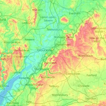
Name: Gloucestershire topographic map, elevation, terrain.
Location: Gloucestershire, England, United Kingdom (51.57753 -2.68754 52.11258 -1.61520)
Average elevation: 99 m
Minimum elevation: -2 m
Maximum elevation: 419 m
Other topographic maps
Click on a map to view its topography, its elevation and its terrain.
London
United Kingdom > England > London
London, Greater London, England, SW1A 2DX, United Kingdom
Average elevation: 42 m
London
London, Greater London, England, United Kingdom
Average elevation: 66 m
Bristol
United Kingdom > England > City of Bristol
Bristol, City of Bristol, West of England, England, United Kingdom
Average elevation: 55 m
Liverpool
Liverpool, Liverpool City Region, England, United Kingdom
Average elevation: 26 m
St Albans
United Kingdom > England > Hertfordshire > St Albans
St Albans, Hertfordshire, East of England, England, United Kingdom
Average elevation: 100 m
Birmingham
Birmingham, West Midlands Combined Authority, England, United Kingdom
Average elevation: 138 m
Sheffield
Sheffield, South Yorkshire, England, United Kingdom
Average elevation: 168 m
Nottingham
United Kingdom > England > Nottinghamshire
Nottingham, England, United Kingdom
Average elevation: 56 m
Greater London
Greater London, England, United Kingdom
Average elevation: 66 m
Lincolnshire
Lincolnshire, East Midlands, England, United Kingdom
Average elevation: 28 m
Oxford
United Kingdom > England > Oxfordshire
Oxford, Oxfordshire, England, United Kingdom
Average elevation: 81 m
Coventry
Coventry, West Midlands Combined Authority, England, United Kingdom
Average elevation: 99 m
South East England
South East England, England, United Kingdom
Average elevation: 69 m
Somerset
Somerset, South West England, England, United Kingdom
Average elevation: 87 m
Leighton Buzzard
United Kingdom > England > Central Bedfordshire
Leighton Buzzard, Central Bedfordshire, England, LU7 1EE, United Kingdom
Average elevation: 103 m
Sutton Coldfield
United Kingdom > England > Birmingham
Sutton Coldfield, Birmingham, West Midlands Combined Authority, England, United Kingdom
Average elevation: 124 m
Cambridge
United Kingdom > England > Cambridge
Cambridge, Cambridgeshire, East of England, England, United Kingdom
Average elevation: 18 m
Hull
United Kingdom > England > Kingston upon Hull
Hull, Kingston upon Hull, England, HU1 3RJ, United Kingdom
Average elevation: 21 m
Greater Manchester
Greater Manchester, England, United Kingdom
Average elevation: 141 m
Leasowe Lighthouse
United Kingdom > England > Moreton
Leasowe Lighthouse, Lingham Lane, Moreton, Wirral, Liverpool City Region, England, CH46 4TB, United Kingdom
Average elevation: 4 m
Lancaster
United Kingdom > England > Lancashire
Lancaster, Lancashire, England, United Kingdom
Average elevation: 84 m
Leeds
United Kingdom > England > Leeds
Leeds, Yorkshire and the Humber, England, LS1 6AL, United Kingdom
Average elevation: 94 m
Wimbledon
Wimbledon, Greater London, England, SW19 7NL, United Kingdom
Average elevation: 26 m
Wirral
Wirral, Liverpool City Region, England, United Kingdom
Average elevation: 21 m
City of London
United Kingdom > England > City of London > City of London
City of London, England, EC2V 5AE, United Kingdom
Average elevation: 42 m
Macclesfield
United Kingdom > England > Macclesfield
Macclesfield, Cheshire East, North West England, England, SK10 1EA, United Kingdom
Average elevation: 189 m
Maidenhead
United Kingdom > England > Royal Borough of Windsor and Maidenhead
Maidenhead, Royal Borough of Windsor and Maidenhead, England, SL6 1QB, United Kingdom
Average elevation: 41 m
Newcastle upon Tyne
Newcastle upon Tyne, North of Tyne, England, United Kingdom
Average elevation: 57 m
Knayton
United Kingdom > England > North Yorkshire
Knayton, North Yorkshire, England, YO7 4AY, United Kingdom
Average elevation: 76 m
Bagby
United Kingdom > England > North Yorkshire
Bagby, North Yorkshire, England, United Kingdom
Average elevation: 48 m
North West England
North West England, England, United Kingdom
Average elevation: 118 m
East Riding of Yorkshire
East Riding of Yorkshire, England, United Kingdom
Average elevation: 30 m
Scunthorpe
United Kingdom > England > North Lincolnshire
Scunthorpe, North Lincolnshire, England, DN15 6SD, United Kingdom
Average elevation: 28 m
Harrogate
United Kingdom > England > North Yorkshire
Harrogate, North Yorkshire, England, United Kingdom
Average elevation: 131 m
Stroud
United Kingdom > England > Gloucestershire
Stroud, Gloucestershire, England, United Kingdom
Average elevation: 113 m
Carlisle
United Kingdom > England > Cumberland
Carlisle, Cumberland, England, United Kingdom
Average elevation: 31 m
Warminster
United Kingdom > England > Wiltshire
Warminster, Wiltshire, England, United Kingdom
Average elevation: 143 m
North Yorkshire
North Yorkshire, Yorkshire and the Humber, England, United Kingdom
Average elevation: 153 m