
La Palma topographic map
Interactive map
Click on the map to display elevation.
About this map
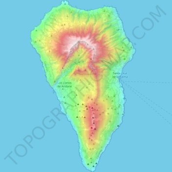
Name: La Palma topographic map, elevation, terrain.
Location: La Palma, Santa Cruz de Tenerife, Canary Islands, Spain (28.45270 -18.00723 28.85789 -17.72422)
Average elevation: 295 m
Minimum elevation: 0 m
Maximum elevation: 2,410 m
Other topographic maps
Click on a map to view its topography, its elevation and its terrain.
Los Llanos de Aridane
Spain > Santa Cruz de Tenerife > Los Llanos de Aridane
Los Llanos de Aridane, Santa Cruz de Tenerife, Canary Islands, Spain
Average elevation: 357 m