
Lučenec topographic map
Interactive map
Click on the map to display elevation.
About this map
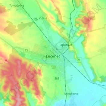
Name: Lučenec topographic map, elevation, terrain.
Average elevation: 210 m
Minimum elevation: 170 m
Maximum elevation: 278 m
Other topographic maps
Click on a map to view its topography, its elevation and its terrain.
Halič
Slovakia > Region of Banská Bystrica > District of Lučenec
Halič, District of Lučenec, Region of Banská Bystrica, Central Slovakia, Slovakia
Average elevation: 254 m