
Khed topographic map
Interactive map
Click on the map to display elevation.
About this map
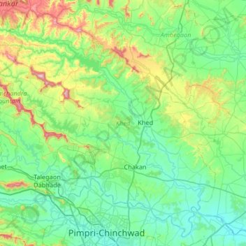
Name: Khed topographic map, elevation, terrain.
Location: Khed, Pune District, Maharashtra, India (18.61924 73.51523 19.08284 74.04459)
Average elevation: 680 m
Minimum elevation: 539 m
Maximum elevation: 1,239 m
Other topographic maps
Click on a map to view its topography, its elevation and its terrain.
Bhimashankar
India > Maharashtra > Khed > Bhimashankar
Bhimashankar, Khed, Maharashtra, India
Average elevation: 741 m
Chakan
India > Maharashtra > Khed
Chakan, Khed, Pune, Maharashtra, 410500, India
Average elevation: 624 m