
Changhua County topographic map
Interactive map
Click on the map to display elevation.
About this map
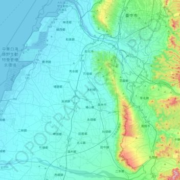
Name: Changhua County topographic map, elevation, terrain.
Location: Changhua County, Taiwan Province, Taiwan (23.78561 120.24224 24.19739 120.68395)
Average elevation: 75 m
Minimum elevation: -2 m
Maximum elevation: 615 m
The County's total area is 1,074 km2 (415 sq mi), being Taiwan's smallest county. It owns a 60 km (37 mi) of coastline. The landscape of Changhua can be roughly divided into two parts, one being the western flat land, and the other being the Changhua Plain. This two combines together measures up to 88% of Changhua county's total area. The highest elevation in Changhua is "Hen Shan", at 443 m (1,453 ft).
Other topographic maps
Click on a map to view its topography, its elevation and its terrain.
Dacheng Township
Taiwan > Taiwan Province > Changhua County > Dacheng Township
Dacheng Township, Changhua County, Taiwan Province, Taiwan
Average elevation: 8 m