
Shepherdsville topographic map
Interactive map
Click on the map to display elevation.
About this map
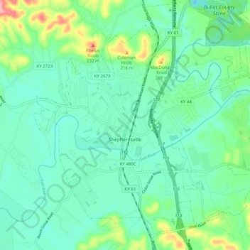
Name: Shepherdsville topographic map, elevation, terrain.
Location: Shepherdsville, Bullitt County, Kentucky, United States (37.96185 -85.75204 38.02428 -85.65332)
Average elevation: 148 m
Minimum elevation: 114 m
Maximum elevation: 261 m
Other topographic maps
Click on a map to view its topography, its elevation and its terrain.
Lebanon Junction
United States > Kentucky > Bullitt County
Lebanon Junction, Bullitt County, Kentucky, United States
Average elevation: 144 m