
Ahmadi topographic map
Interactive map
Click on the map to display elevation.
About this map
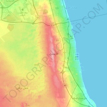
Name: Ahmadi topographic map, elevation, terrain.
Location: Ahmadi, East Ahmadi, Ahmadi Governorate, 60012, Kuwait (28.92907 47.90102 29.24907 48.22102)
Average elevation: 43 m
Minimum elevation: -1 m
Maximum elevation: 127 m
Other topographic maps
Click on a map to view its topography, its elevation and its terrain.