
Ningo-Prampram District topographic map
Interactive map
Click on the map to display elevation.
About this map
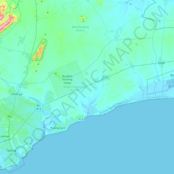
Name: Ningo-Prampram District topographic map, elevation, terrain.
Location: Ningo-Prampram District, Greater Accra Region, Ghana (5.69364 -0.07102 5.93568 0.35884)
Average elevation: 31 m
Minimum elevation: -3 m
Maximum elevation: 439 m
Other topographic maps
Click on a map to view its topography, its elevation and its terrain.
Lapaz
Ghana > Greater Accra Region > Okaikwei North Municipal District > Accra
Average elevation: 40 m
Oyarifa
Ghana > Greater Accra Region > La-Nkwantanang-Madina Municipal District
Average elevation: 108 m
Dzorwulu
Ghana > Greater Accra Region > Ayawaso West Municipal District > Accra
Average elevation: 46 m
Abeka
Ghana > Greater Accra Region > Okaikwei North Municipal District > Accra
Average elevation: 36 m
La
Ghana > Greater Accra Region > La-Dade-Kotopon Municipal District > Accra > La
Average elevation: 16 m
Achimota
Ghana > Greater Accra Region > Okaikwei North Municipal District > Accra > Achimota
Average elevation: 45 m