
Deadwood topographic map
Interactive map
Click on the map to display elevation.
About this map
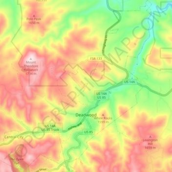
Name: Deadwood topographic map, elevation, terrain.
Average elevation: 1,511 m
Minimum elevation: 1,265 m
Maximum elevation: 1,735 m
Other topographic maps
Click on a map to view its topography, its elevation and its terrain.
Terry Peak
United States > South Dakota > Lawrence County
Terry Peak, Lawrence County, South Dakota, United States
Average elevation: 1,940 m
Spearfish
United States > South Dakota > Lawrence County > Spearfish
Spearfish, Lawrence County, South Dakota, 57783, United States
Average elevation: 1,291 m
Spearfish
United States > South Dakota > Lawrence County
Spearfish, Lawrence County, South Dakota, United States
Average elevation: 1,171 m
Lead
United States > South Dakota > Lawrence County
Lead, Lawrence County, South Dakota, United States
Average elevation: 1,605 m