
Mountainburg topographic map
Interactive map
Click on the map to display elevation.
About this map
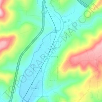
Name: Mountainburg topographic map, elevation, terrain.
Location: Mountainburg, Crawford County, Arkansas, United States (35.61522 -94.18205 35.66113 -94.15564)
Average elevation: 304 m
Minimum elevation: 207 m
Maximum elevation: 497 m
Other topographic maps
Click on a map to view its topography, its elevation and its terrain.
Natural Dam
United States > Arkansas > Crawford County
Natural Dam, Crawford County, Arkansas, 72948, United States
Average elevation: 246 m