
Richmond County topographic map
Interactive map
Click on the map to display elevation.
About this map
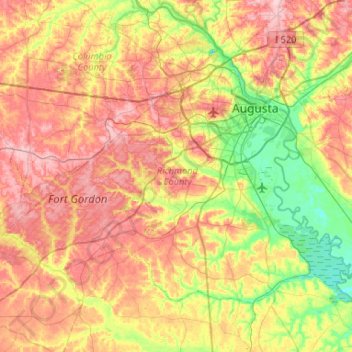
Name: Richmond County topographic map, elevation, terrain.
Location: Richmond County, Georgia, United States (33.22717 -82.35387 33.54502 -81.82812)
Average elevation: 96 m
Minimum elevation: 22 m
Maximum elevation: 177 m
Other topographic maps
Click on a map to view its topography, its elevation and its terrain.
Augusta Canal
United States > Georgia > Richmond County > Augusta
Augusta Canal, Augusta, Richmond County, Georgia, United States
Average elevation: 80 m
Dorchester
United States > Georgia > Richmond County > Augusta
Dorchester, Augusta, Richmond County, Georgia, 30909, United States
Average elevation: 90 m
Forest Acres
United States > Georgia > Richmond County > Augusta
Forest Acres, Augusta, Richmond County, Georgia, 30904, United States
Average elevation: 67 m
Fairvale
United States > Georgia > Richmond County > Augusta
Fairvale, Augusta, Richmond County, Georgia, 30906, United States
Average elevation: 56 m
Ellwood
United States > Georgia > Richmond County > Augusta
Ellwood, Augusta, Richmond County, Georgia, United States
Average elevation: 119 m
Berckman Villas
United States > Georgia > Richmond County > Augusta > Berckman Villas
Berckman Villas, Augusta, Richmond County, Georgia, 30904, United States
Average elevation: 87 m
Fort Gordon
United States > Georgia > Richmond County > Augusta > Fort Gordon
Fort Gordon, Augusta, Richmond County, Georgia, 30905, United States
Average elevation: 136 m
Augusta
United States > Georgia > Richmond County
Augusta, Richmond County, Georgia, United States
Average elevation: 89 m