
Make a donation
Guimaras topographic map
Interactive map
Click on the map to display elevation.


Guimaras
Mount Bontoc is the highest point in the province of Guimaras with an elevation of 892 ft (272 m) above sea level, located in municipality of Sibunag. Mount Dinulman is the second highest mountain with an elevation of 879 ft (268 m) also located in Sibunag.
About this map
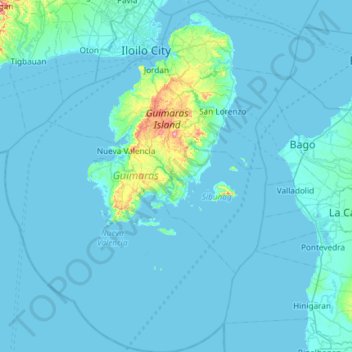
Name: Guimaras topographic map, elevation, terrain.
Location: Guimaras, Western Visayas, Philippines (10.19397 122.33709 10.77440 122.83021)
Average elevation: 13 m
Minimum elevation: -2 m
Maximum elevation: 270 m
Other topographic maps
Click on a map to view its topography, its elevation and its terrain.
Ayala Westgrove Heights
Philippines > Cavite > Puting Kahoy > Ayala Westgrove Heights
Average elevation: 161 m
Antipolo
Its higher elevation than that of Metro Manila affords it a scenic view of the metropolis, especially at night. Its locally grown mangoes and cashews are popular among tourists, as well as suman – a local delicacy made out of glutinous rice. The Hinulugang Taktak National Park, which was once a popular…
Average elevation: 125 m
Lake Apo
Philippines > Bukidnon > Valencia
Lake Apo is a crater lake in Barangay Guinoyoran in the city of Valencia in Bukidnon province in the Philippines. It is located in a hilly area about 640 metres (2,100 ft) in elevation, about 11 kilometres (6.8 mi) WSW of the city poblacion (town center). Lake Apo was awarded the cleanest inland body of water…
Average elevation: 643 m
Bayang
The topography of the municipality is generally characterized by moderately sloping lands. Approximately 2,606 hectares (63.45%) have moderate slopes of 8 – 15%. Steep lands with a slope 40 – 60% comprise 20.14% (827) ha. About 674 (16.41) have nearly level terrain.
Average elevation: 782 m
Kanlaon
Philippines > Negros Occidental > La Castellana
Kanlaon, also known as Mount Kanlaon and Kanlaon Volcano (Hiligaynon: Bolkang Kanglaon; Cebuano: Bolkang Kanglaon; Filipino: Bulkang Kanlaon), is an active andesitic stratovolcano and the highest mountain on the island of Negros in the Philippines, as well as the highest peak in the Visayas, with an elevation…
Average elevation: 1,959 m
Calabanga
The topographic landscape of the municipality could be characterized as generally flat with a slope 0-3%, gently sloping (3-8%) towards the direction of the eastern portion and finally rolling up to higher steeps towards the direction of the south-eastern part going to Mt. Isarog. The 0-3% slope is a broad…
Average elevation: 11 m
Mount Labo
Philippines > Quezon > Tagkawayan
Labo is a forested andesitic stratovolcano, surrounded by numerous andesitic to dacitic satellite lava domes. It has an elevation of 1,544 metres (5,066 ft) asl. Base diameter of this complex volcano is 35 kilometres (22 mi). Labo is thermally active with both warm and hot springs.
Average elevation: 1,052 m