
Dolbeare topographic map
Interactive map
Click on the map to display elevation.
About this map
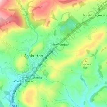
Name: Dolbeare topographic map, elevation, terrain.
Average elevation: 127 m
Minimum elevation: 44 m
Maximum elevation: 272 m
Other topographic maps
Click on a map to view its topography, its elevation and its terrain.
Hele
United Kingdom > England > Devon > Teignbridge > Ashburton
Hele, Ashburton, Teignbridge, Devon, England, TQ13 7QX, United Kingdom
Average elevation: 137 m
Ashburton
United Kingdom > England > Devon > Teignbridge > Ashburton
Ashburton, Teignbridge, Devon, England, United Kingdom
Average elevation: 163 m
Caton
United Kingdom > England > Devon > Teignbridge > Ashburton
Caton, Ashburton, Teignbridge, Devon, England, TQ13 7EU, United Kingdom
Average elevation: 138 m