
Kotdwar topographic map
Interactive map
Click on the map to display elevation.
About this map
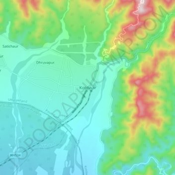
Name: Kotdwar topographic map, elevation, terrain.
Average elevation: 471 m
Minimum elevation: 324 m
Maximum elevation: 910 m
Kotdwar lies on the western margin of the Himalayas, at an altitude of 454 m (1,490 ft) above sea level.
Other topographic maps
Click on a map to view its topography, its elevation and its terrain.
Dugadda
India > Uttarakhand > Kotdwara
Dugadda, Kotdwara, Pauri Garhwal District, Uttarakhand, India
Average elevation: 896 m
Ramganga Dam
India > Uttarakhand > Kotdwara
Ramganga Dam, Kotdwara, Pauri Garhwal, Uttarakhand, India
Average elevation: 389 m