
Pampanga River topographic map
Interactive map
Click on the map to display elevation.
About this map
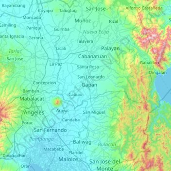
Name: Pampanga River topographic map, elevation, terrain.
Location: Pampanga River, Pampanga, Central Luzon, 2017, Philippines (14.76872 120.65394 15.60826 121.20878)
Average elevation: 127 m
Minimum elevation: -1 m
Maximum elevation: 1,713 m
Other topographic maps
Click on a map to view its topography, its elevation and its terrain.
Clark
The development is not a flood-prone area with its minimum elevation being at 54 metres (177 ft) above sea level and its planned central park also serves as a flood catchment basin. The Sierra Madre mountain range is located on the development's east while the Zambales mountain range is located on the west,…
Average elevation: 190 m