
Sumter topographic map
Interactive map
Click on the map to display elevation.
About this map
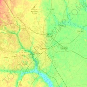
Name: Sumter topographic map, elevation, terrain.
Location: Sumter, Sumter County, South Carolina, United States (33.86331 -80.49367 33.99540 -80.30607)
Average elevation: 48 m
Minimum elevation: 27 m
Maximum elevation: 69 m
Other topographic maps
Click on a map to view its topography, its elevation and its terrain.
Cane Savannah
United States > South Carolina > Sumter County
Cane Savannah, Sumter County, South Carolina, 29154, United States
Average elevation: 52 m