
Mizan Teferi topographic map
Interactive map
Click on the map to display elevation.
About this map
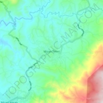
Name: Mizan Teferi topographic map, elevation, terrain.
Location: Mizan Teferi, Bench Maji, South West Ethiopia Peoples, Ethiopia (6.95529 35.54689 7.03529 35.62689)
Average elevation: 1,484 m
Minimum elevation: 1,251 m
Maximum elevation: 2,224 m
Mizan Tefere (also called simply Mizan) is a town and the administrative center, of the Bench Sheko Zone in the South West Ethiopia Peoples' Region of Ethiopia. Located about 160 kilometers southwest of Jimma, Mizan Tefere has a latitude and longitude of 7°0′N 35°35′E / 7.000°N 35.583°E / 7.000; 35.583Coordinates: 7°0′N 35°35′E / 7.000°N 35.583°E / 7.000; 35.583 and an elevation of 1451 meters. Mizan Teferi, together with the neighboring town of Aman, forms a separate woreda called Mizan Aman. This is surrounded by Debub Bench woreda.