
Make a donation
Gear up for your next adventure:
As an Amazon Associate, this site earns from qualifying purchases at no extra cost to you.
Prudnik topographic map
Click on the map to display elevation.
Make a donation
Gear up for your next adventure:
As an Amazon Associate, this site earns from qualifying purchases at no extra cost to you.
Prudnik
In the 19th century, the city's name was changed to Neustadt in Oberschlesien ("New Town in Upper Silesia"), while the Slavic name Prudnik was still used by its Polish inhabitants, which was mentioned in Upper Silesia's topographical description from 1865: "Der ursprünglische Stadtname "Prudnik" ist noch jetz bei den polnischen Landbewohnern üblich". In the alphabetic list of cities of Silesia published by Johann Knie in Wrocław in 1830, Polish name Prudnik was used along with German Neustadt ("Prudnik, polnische Benennung der Kreistadt Neustadt").
Make a donation
Gear up for your next adventure:
As an Amazon Associate, this site earns from qualifying purchases at no extra cost to you.
About this map
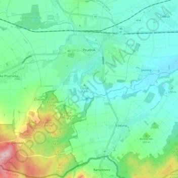
Name: Prudnik topographic map, elevation, terrain.
Average elevation: 282 m
Minimum elevation: 228 m
Maximum elevation: 448 m
Make a donation
Gear up for your next adventure:
As an Amazon Associate, this site earns from qualifying purchases at no extra cost to you.