
Centralia topographic map
Interactive map
Click on the map to display elevation.
About this map
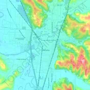
Name: Centralia topographic map, elevation, terrain.
Location: Centralia, Lewis County, Washington, United States (46.69155 -123.01989 46.75665 -122.92395)
Average elevation: 74 m
Minimum elevation: 43 m
Maximum elevation: 195 m
Other topographic maps
Click on a map to view its topography, its elevation and its terrain.
Ceres
United States > Washington > Lewis County
Ceres, Lewis County, Washington, United States
Average elevation: 123 m
Toledo
United States > Washington > Lewis County
Toledo, Lewis County, Washington, United States
Average elevation: 49 m
Riffe Lake
United States > Washington > Lewis County
Riffe Lake, Lewis County, Washington, United States
Average elevation: 503 m
Mossyrock
United States > Washington > Lewis County
Mossyrock, Lewis County, Washington, United States
Average elevation: 213 m
Ike Kinswa State Park
United States > Washington > Lewis County
Ike Kinswa State Park, Lewis County, Washington, United States
Average elevation: 187 m
Chehalis
United States > Washington > Lewis County
Chehalis, Lewis County, Washington, United States
Average elevation: 81 m
Winlock
United States > Washington > Lewis County
Winlock, Lewis County, Washington, United States
Average elevation: 124 m
Ham Hill
United States > Washington > Lewis County > Centralia
Ham Hill, Centralia, Lewis County, Washington, United States
Average elevation: 101 m
The Rockies
United States > Washington > Lewis County
The Rockies, Lewis County, Washington, United States
Average elevation: 1,012 m
Napavine
United States > Washington > Lewis County > Napavine
Napavine, Lewis County, Washington, 98565, United States
Average elevation: 105 m
Onalaska
United States > Washington > Lewis County
Onalaska, Lewis County, Washington, 98542, United States
Average elevation: 170 m