Geolocate

Cape Blanco topographic map

Interactive map

Click on the map to display elevation.

About this map

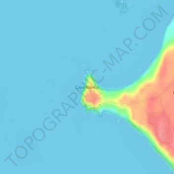
Name: Cape Blanco topographic map, elevation, terrain.

Location: Cape Blanco, Curry County, Oregon, United States (42.83577 -124.56506 42.83587 -124.56496)

Average elevation: 8 m

Minimum elevation: 0 m

Maximum elevation: 74 m

Other topographic maps

Click on a map to view its topography, its elevation and its terrain.

Brookings

United States > Oregon > Curry County

Average elevation: 131 m

Harbor

United States > Oregon > Curry County > Harbor

Average elevation: 71 m

Gold Beach

United States > Oregon > Curry County

Average elevation: 85 m

Port Orford

United States > Oregon > Curry County

Average elevation: 33 m

Port Orford

United States > Oregon > Curry County

Average elevation: 33 m

Gold Beach

United States > Oregon > Curry County

Average elevation: 85 m

Brookings

United States > Oregon > Curry County

Average elevation: 131 m