
Bishop's Stortford topographic map
Interactive map
Click on the map to display elevation.
About this map
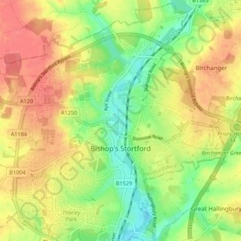
Name: Bishop's Stortford topographic map, elevation, terrain.
Average elevation: 83 m
Minimum elevation: 52 m
Maximum elevation: 111 m
Stortford, along with the rest of Britain, has a temperate maritime climate, with cool summers and mild winters. The nearest weather station for which averages and extremes are available is Stansted Airport, about 2+1⁄2 miles (4 kilometres) due east of Stortford's town centre. Located at an elevation of over 100 m, the weather station, and parts of Stortford in general are marginally cooler throughout the year than the Cambridgeshire area to the north or the London area to the south. Nonetheless, Stortford is still warmer than the English average.
Other topographic maps
Click on a map to view its topography, its elevation and its terrain.
Astonbury Wood
United Kingdom > England > Hertfordshire > East Hertfordshire > Aston
Astonbury Wood, Aston, East Hertfordshire, Hertfordshire, England, United Kingdom
Average elevation: 83 m
Stanstead St Margarets
United Kingdom > England > Hertfordshire > East Hertfordshire
Stanstead St Margarets, East Hertfordshire, Hertfordshire, England, SG12 8DH, United Kingdom
Average elevation: 48 m
Burnham Green
United Kingdom > England > Hertfordshire > East Hertfordshire
Burnham Green, East Hertfordshire, Hertfordshire, England, AL6 0HA, United Kingdom
Average elevation: 102 m
Furneux Pelham
United Kingdom > England > Hertfordshire > East Hertfordshire
Furneux Pelham, East Hertfordshire, Hertfordshire, England, United Kingdom
Average elevation: 113 m
Chapmore End
United Kingdom > England > Hertfordshire > East Hertfordshire > Tonwell
Chapmore End, Bengeo Rural, Tonwell, East Hertfordshire, Hertfordshire, England, SG12 0HF, United Kingdom
Average elevation: 65 m
King's Meads
United Kingdom > England > Hertfordshire > East Hertfordshire > Ware
King's Meads, Glaxo Footbridge, Kings Hill, Ware, East Hertfordshire, Hertfordshire, England, SG12 0GG, United Kingdom
Average elevation: 53 m
Benington
United Kingdom > England > Hertfordshire > East Hertfordshire
Benington, East Hertfordshire, Hertfordshire, England, SG2 7LA, United Kingdom
Average elevation: 106 m
Broken Green
United Kingdom > England > Hertfordshire > East Hertfordshire
Broken Green, Standon, East Hertfordshire, Hertfordshire, England, SG11 1NH, United Kingdom
Average elevation: 97 m
Little Amwell
United Kingdom > England > Hertfordshire > East Hertfordshire
Little Amwell, East Hertfordshire, Hertfordshire, England, SG13 7QX, United Kingdom
Average elevation: 65 m
Spellbrook
United Kingdom > England > Hertfordshire > East Hertfordshire > Sawbridgeworth
Spellbrook, Sawbridgeworth, East Hertfordshire, Hertfordshire, England, CM23 4RE, United Kingdom
Average elevation: 71 m
Westmill
United Kingdom > England > Hertfordshire > East Hertfordshire
Westmill, East Hertfordshire, Hertfordshire, England, United Kingdom
Average elevation: 108 m
Hertingfordbury
United Kingdom > England > Hertfordshire > East Hertfordshire
Hertingfordbury, East Hertfordshire, Hertfordshire, England, SG14 2LD, United Kingdom
Average elevation: 61 m
Aston
United Kingdom > England > Hertfordshire > East Hertfordshire
Aston, East Hertfordshire, Hertfordshire, England, United Kingdom
Average elevation: 99 m
Tewin Wood
United Kingdom > England > Hertfordshire > East Hertfordshire > Burnham Green
Tewin Wood, Tewin, Burnham Green, East Hertfordshire, Hertfordshire, England, AL6 0NU, United Kingdom
Average elevation: 101 m
Puckeridge
United Kingdom > England > Hertfordshire > East Hertfordshire
Puckeridge, East Hertfordshire, Hertfordshire, England, SG11 1RD, United Kingdom
Average elevation: 98 m
Wyddial
United Kingdom > England > Hertfordshire > East Hertfordshire
Wyddial, East Hertfordshire, Hertfordshire, England, SG9 0UH, United Kingdom
Average elevation: 114 m
Throcking
United Kingdom > England > Hertfordshire > East Hertfordshire > Buntingford
Throcking, Cottered, Buntingford, East Hertfordshire, Hertfordshire, England, SG9 9RU, United Kingdom
Average elevation: 126 m
Bayford
United Kingdom > England > Hertfordshire > East Hertfordshire
Bayford, East Hertfordshire, Hertfordshire, England, United Kingdom
Average elevation: 83 m
Hertford
United Kingdom > England > Hertfordshire > East Hertfordshire
Hertford, East Hertfordshire, Hertfordshire, England, United Kingdom
Average elevation: 61 m
Braughing
United Kingdom > England > Hertfordshire > East Hertfordshire
Braughing, East Hertfordshire, Hertfordshire, England, United Kingdom
Average elevation: 104 m
Moor Green
United Kingdom > England > Hertfordshire > East Hertfordshire > Ardeley
Moor Green, Ardeley, East Hertfordshire, Hertfordshire, England, SG2 7AS, United Kingdom
Average elevation: 123 m
Hertingfordbury
United Kingdom > England > Hertfordshire > East Hertfordshire
Hertingfordbury, East Hertfordshire, Hertfordshire, England, United Kingdom
Average elevation: 68 m
Gilston
United Kingdom > England > Hertfordshire > East Hertfordshire
Gilston, East Hertfordshire, Hertfordshire, England, United Kingdom
Average elevation: 59 m
Letty Green
United Kingdom > England > Hertfordshire > East Hertfordshire
Letty Green, East Hertfordshire, Hertfordshire, England, SG14 2NS, United Kingdom
Average elevation: 69 m
Dassels
United Kingdom > England > Hertfordshire > East Hertfordshire > Dassels
Dassels, East Hertfordshire, Hertfordshire, East of England, England, SG11 2RW, United Kingdom
Average elevation: 104 m
Buntingford
United Kingdom > England > Hertfordshire > East Hertfordshire
Buntingford, East Hertfordshire, Hertfordshire, England, United Kingdom
Average elevation: 110 m
Hertford Heath Nature Reserve
United Kingdom > England > Hertfordshire > East Hertfordshire > Little Amwell
Hertford Heath Nature Reserve, Bride's Farm, Hertford Heath, Little Amwell, East Hertfordshire, Hertfordshire, England, United Kingdom
Average elevation: 79 m
Painter's Green
United Kingdom > England > Hertfordshire > East Hertfordshire > Datchworth
Painter's Green, Datchworth, East Hertfordshire, Hertfordshire, England, SG3 6ST, United Kingdom
Average elevation: 100 m
Hare Street
United Kingdom > England > Hertfordshire > East Hertfordshire > Great Hormead
Hare Street, Hormead, Great Hormead, East Hertfordshire, Hertfordshire, England, SG9 0DZ, United Kingdom
Average elevation: 110 m
Standon
United Kingdom > England > Hertfordshire > East Hertfordshire
Standon, East Hertfordshire, Hertfordshire, England, United Kingdom
Average elevation: 97 m
Waterford
United Kingdom > England > Hertfordshire > East Hertfordshire > Waterford
Waterford, East Hertfordshire, Hertfordshire, East of England, England, SG14 2PR, United Kingdom
Average elevation: 66 m
Sawbridgeworth
United Kingdom > England > Hertfordshire > East Hertfordshire > Sawbridgeworth
Sawbridgeworth, East Hertfordshire, Hertfordshire, England, United Kingdom
Average elevation: 67 m
Meesden
United Kingdom > England > Hertfordshire > East Hertfordshire
Meesden, East Hertfordshire, Hertfordshire, England, United Kingdom
Average elevation: 126 m
Hertford Heath
United Kingdom > England > Hertfordshire > East Hertfordshire
Hertford Heath, Little Amwell, East Hertfordshire, Hertfordshire, England, United Kingdom
Average elevation: 74 m
Baker's End
United Kingdom > England > Hertfordshire > East Hertfordshire > Wareside > Baker's End
Baker's End, Wareside, East Hertfordshire, Hertfordshire, East of England, England, SG12 7SH, United Kingdom
Average elevation: 73 m
Tewin
United Kingdom > England > Hertfordshire > East Hertfordshire
Tewin, East Hertfordshire, Hertfordshire, England, United Kingdom
Average elevation: 91 m
Much Hadham
United Kingdom > England > Hertfordshire > East Hertfordshire
Much Hadham, East Hertfordshire, Hertfordshire, England, United Kingdom
Average elevation: 80 m
Widford
United Kingdom > England > Hertfordshire > East Hertfordshire
Widford, East Hertfordshire, Hertfordshire, England, United Kingdom
Average elevation: 73 m
Thorley
United Kingdom > England > Hertfordshire > East Hertfordshire
Thorley, East Hertfordshire, Hertfordshire, England, United Kingdom
Average elevation: 82 m
High Wych
United Kingdom > England > Hertfordshire > East Hertfordshire
High Wych, East Hertfordshire, Hertfordshire, England, United Kingdom
Average elevation: 70 m
Little Berkhamsted
United Kingdom > England > Hertfordshire > East Hertfordshire
Little Berkhamsted, East Hertfordshire, Hertfordshire, England, United Kingdom
Average elevation: 88 m
Ware
United Kingdom > England > Hertfordshire > East Hertfordshire
Ware, East Hertfordshire, Hertfordshire, England, United Kingdom
Average elevation: 55 m
Little Hadham
United Kingdom > England > Hertfordshire > East Hertfordshire
Little Hadham, East Hertfordshire, Hertfordshire, England, SG11 2DG, United Kingdom
Average elevation: 96 m
Brent Pelham
United Kingdom > England > Hertfordshire > East Hertfordshire
Brent Pelham, East Hertfordshire, Hertfordshire, England, SG9 0HN, United Kingdom
Average elevation: 121 m
Great Amwell
United Kingdom > England > Hertfordshire > East Hertfordshire
Great Amwell, East Hertfordshire, Hertfordshire, England, SG12 9SW, United Kingdom
Average elevation: 53 m
Epping Green
United Kingdom > England > Hertfordshire > East Hertfordshire
Epping Green, East Hertfordshire, Hertfordshire, England, SG13 8NG, United Kingdom
Average elevation: 103 m
Walkern
United Kingdom > England > Hertfordshire > East Hertfordshire
Walkern, East Hertfordshire, Hertfordshire, England, United Kingdom
Average elevation: 112 m
Wadesmill
United Kingdom > England > Hertfordshire > East Hertfordshire
Wadesmill, East Hertfordshire, Hertfordshire, England, SG12 0TY, United Kingdom
Average elevation: 78 m
Brickendon
United Kingdom > England > Hertfordshire > East Hertfordshire
Brickendon, East Hertfordshire, Hertfordshire, England, SG13 8PF, United Kingdom
Average elevation: 87 m
Watton-at-Stone
United Kingdom > England > Hertfordshire > East Hertfordshire
Watton-at-Stone, East Hertfordshire, Hertfordshire, England, SG14 3TF, United Kingdom
Average elevation: 86 m