
Milne Land topographic map
Interactive map
Click on the map to display elevation.
About this map
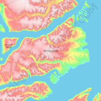
Name: Milne Land topographic map, elevation, terrain.
Location: Milne Land, Greenland (70.41369 -28.06595 71.08568 -25.26718)
Average elevation: 688 m
Minimum elevation: -2 m
Maximum elevation: 2,204 m
Other topographic maps
Click on a map to view its topography, its elevation and its terrain.
Jakobshavn Glacier
Jakobshavn Glacier, Avannaata, Greenland
Average elevation: 452 m
Ittoqqortoormiit
Ittoqqortoormiit, Sermersooq, 3980, Greenland
Average elevation: 80 m
Kangerlussuaq
Kangerlussuaq, Sisimiut, Qeqqata, Greenland
Average elevation: 114 m
Traill-iup Immikkeertivi
Traill-iup Immikkeertivi, Sermersooq, Greenland
Average elevation: 0 m
Geographical Society Island
Geographical Society Island, Sermersooq, Greenland
Average elevation: 178 m