Geolocate

Quriyat topographic map

Interactive map

Click on the map to display elevation.

About this map

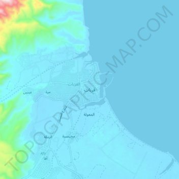
Name: Quriyat topographic map, elevation, terrain.

Location: Quriyat, Muscat Governorate, Oman (23.22104 58.88027 23.30104 58.96027)

Average elevation: 33 m

Minimum elevation: -2 m

Maximum elevation: 534 m

Other topographic maps

Click on a map to view its topography, its elevation and its terrain.

Al Khuwair

Oman > Muscat Governorate > Bawshar Province

Average elevation: 72 m

Qantab

Oman > Muscat Governorate

Average elevation: 97 m

Ghala

Oman > Muscat Governorate > Bawshar Province

Average elevation: 131 m

Bawshar Province

Oman > Muscat Governorate

Average elevation: 222 m

Hayy al Irfan

Oman > Muscat Governorate > Seeb Province

Average elevation: 58 m

Eastern Islands

Oman > Muscat Governorate

Average elevation: 0 m

Western Islands

Oman > Muscat Governorate

Average elevation: 0 m

Muscat

Oman > Muscat Governorate

Average elevation: 134 m

Muscat

Oman > Muscat Governorate

Average elevation: 134 m

Muscat

Oman > Muscat Governorate

Average elevation: 134 m