
Elgeyo-Marakwet County topographic map
Interactive map
Click on the map to display elevation.
About this map
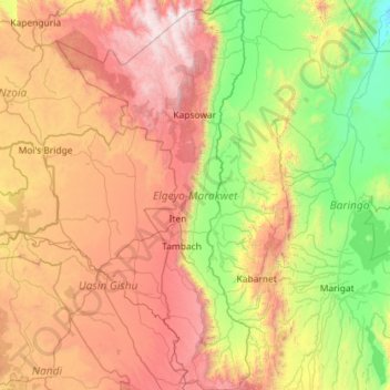
Name: Elgeyo-Marakwet County topographic map, elevation, terrain.
Location: Elgeyo-Marakwet County, Rift Valley, Kenya (0.16787 35.15229 1.31682 35.72309)
Average elevation: 1,730 m
Minimum elevation: 675 m
Maximum elevation: 3,506 m
The Kerio River binds the county on the eastern side. From its alluvial plain the topography gradually rises towards the west. The Elgeyo Escarpment stands out distinctly and causes elevation differences of up to 1,500 m. In the northern and southern part of the county the topography is rugged, giving way to more subdued relief differences going westwards. The underlying geology mainly consists of gneisses from the Basement System. The Cherangany Hills rise gently to form the western half of the Great Rift Valley and extend northwest in a broken chain to Mount Moroto in Uganda. Non-volcanic in origin, the Cherangany Hills resulted from subsequent erosion of the raised western ridge of the Eastern Rift Valley. The range is approximately 30 miles (48 km) long and 25 miles (40 km) wide and averages 9,000 feet (2,700 metres) in height; its highest point reaches more than 11,000 feet (3,370 metres). Many of the summits are covered with huge groundsels and lobelias. Some of the hills include Kameleogon (3581 m), Chebon (3375 m), Chepkotet (3370 m), Alaleigelat (3350 m) and Sodang (3211 m).
Other topographic maps
Click on a map to view its topography, its elevation and its terrain.
Nairobi
Kenya > Nairobi County > Starehe
Nairobi, Nairobi County, Nairobi, Kenya
Average elevation: 1,729 m
Nessuit
Kenya > Nakuru > Rongai > Visoi ward
Nessuit, Visoi ward, Rongai, Nakuru, Rift Valley, Kenya
Average elevation: 1,727 m
Machinery
Kenya > Makueni > Kibwezi East
Machinery, Kibwezi East, Makueni, Eastern, Kenya
Average elevation: 896 m
Ikutha
Kenya > Kitui County > Kitui South
Ikutha, Kitui South, Kitui County, Eastern, Kenya
Average elevation: 696 m
Nyamonye
Kenya > Siaya County > Bondo > Yimbo East ward
Nyamonye, Yimbo East ward, Bondo, Siaya County, Kenya
Average elevation: 1,164 m
Kiawara
Kenya > Nyeri > Kieni West
Kiawara, Kieni West, Nyeri, Central Kenya, Kenya
Average elevation: 2,041 m
Baawa ward
Kenya > Samburu > Samburu Central
Baawa ward, Samburu Central, Samburu, Rift Valley, Kenya
Average elevation: 1,535 m
Amboseli National Park
Kenya > Kajiado County > Amboseli
Amboseli National Park, Hyena Road, Amboseli, Kajiado County, Kenya
Average elevation: 1,161 m
Wodanga ward
Kenya > Vihiga County > Sabatia
Wodanga ward, Sabatia, Vihiga County, Western, Kenya
Average elevation: 1,643 m
Andingo Bware
Kenya > Kisumu County > Nyakach > South West Nyakach ward
Andingo Bware, South West Nyakach ward, Nyakach, Kisumu County, Kenya
Average elevation: 1,431 m
Tudor ward
Kenya > Mombasa County > Mvita > Tudor ward
Tudor ward, Mvita, Mombasa County, Coast, Kenya
Average elevation: 15 m
Kisegi
Kenya > Homa Bay County > Suba > Gwassi North ward
Kisegi, Gwassi North ward, Suba, Homa Bay County, Kenya
Average elevation: 1,157 m
Magunga
Kenya > Homa Bay County > Suba > Gwassi South ward
Magunga, Gwassi South ward, Suba, Homa Bay County, Kenya
Average elevation: 1,353 m
Othoro
Kenya > Homa Bay County > Kabondo Kasipul > Kabondo East ward
Othoro, Kabondo East ward, Kabondo Kasipul, Homa Bay County, Kenya
Average elevation: 1,570 m
Sena
Kenya > Homa Bay County > Mbita > Mfangano Island ward
Sena, Mfangano Island ward, Mbita, Homa Bay County, Kenya
Average elevation: 1,168 m
Baringo Central
Baringo Central, Baringo, Rift Valley, 30400, Kenya
Average elevation: 1,622 m
Metta
Kenya > Nakuru > Njoro > Mau Narok ward
Metta, Mau Narok ward, Njoro, Nakuru, Rift Valley, Kenya
Average elevation: 2,546 m
Barut ward
Kenya > Nakuru > Nakuru West
Barut ward, Nakuru West, Nakuru, Rift Valley, Kenya
Average elevation: 1,888 m
Melelo ward
Kenya > Narok > Narok South
Melelo ward, Narok South, Narok, Rift Valley, Kenya
Average elevation: 2,106 m
Nkareta ward
Kenya > Narok > Narok North
Nkareta ward, Narok North, Narok, Rift Valley, Kenya
Average elevation: 2,118 m
Nanyuki
Kenya > Laikipia County > Laikipia East
Nanyuki, Laikipia East, Laikipia County, Rift Valley, Kenya
Average elevation: 1,937 m
Marakwet West
Kenya > Elgeyo-Marakwet County
Marakwet West, Elgeyo-Marakwet County, Rift Valley, Kenya
Average elevation: 2,056 m
Chesoi
Kenya > Elgeyo-Marakwet County > Marakwet West
Chesoi, Marakwet West, Elgeyo-Marakwet County, Rift Valley, Kenya
Average elevation: 1,958 m
Jaribuni ward
Kenya > Kilifi County > Ganze
Jaribuni ward, Ganze, Kilifi County, Kenya
Average elevation: 167 m
Kiplombe ward
Kenya > Uasin Gishu County > Turbo
Kiplombe ward, Turbo, Uasin Gishu County, Rift Valley, Kenya
Average elevation: 2,033 m
Jikaze
Kenya > Nakuru > Naivasha > Mai Mahiu ward
Jikaze, Mai Mahiu ward, Naivasha, Nakuru, Rift Valley, Kenya
Average elevation: 1,971 m
Korr
Kenya > Marsabit County > Korr/Ngurunit ward
Korr, Korr/Ngurunit ward, Marsabit County, Eastern, Kenya
Average elevation: 552 m
Longonot
Kenya > Nakuru > Naivasha > Mai Mahiu ward
Longonot, Mai Mahiu ward, Naivasha, Nakuru, Rift Valley, Kenya
Average elevation: 2,439 m
Isiolo
Kenya > Meru County > Buuri
Isiolo, Buuri, Meru County, Eastern, Kenya
Average elevation: 1,491 m
Kulesa
Kenya > Tana River County > Garsen
Kulesa, Garsen, Tana River County, Kenya
Average elevation: 18 m
Laikipia West
Laikipia West, Laikipia County, Rift Valley, 20300, Kenya
Average elevation: 1,767 m