
Oued Endja topographic map
Interactive map
Click on the map to display elevation.
About this map
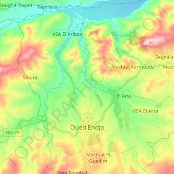
Name: Oued Endja topographic map, elevation, terrain.
Location: Oued Endja, Oued Endja District, Mila, 43006, Algeria (36.40516 6.07207 36.49884 6.19635)
Average elevation: 341 m
Minimum elevation: 180 m
Maximum elevation: 601 m
Other topographic maps
Click on a map to view its topography, its elevation and its terrain.
Zeghaïa
Algeria > Mila > Oued Endja District > Zeghaïa
Zeghaïa, Oued Endja District, Mila, 43012, Algeria
Average elevation: 359 m