
Make a donation
Gear up for your next adventure:
As an Amazon Associate, this site earns from qualifying purchases at no extra cost to you.
Trig Point topographic map
Click on the map to display elevation.
Make a donation
Gear up for your next adventure:
As an Amazon Associate, this site earns from qualifying purchases at no extra cost to you.
About this map
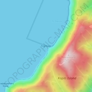
Name: Trig Point topographic map, elevation, terrain.
Location: Trig Point, Wellington, New Zealand (-40.84567 174.90692 -40.84557 174.90702)
Average elevation: 136 m
Minimum elevation: 0 m
Maximum elevation: 498 m
Make a donation
Gear up for your next adventure:
As an Amazon Associate, this site earns from qualifying purchases at no extra cost to you.
Other topographic maps
Click on a map to view its topography, its elevation and its terrain.
Cook Strait
The strait is named after James Cook, the first European commander to sail through it, in 1770. The waters of Cook Strait are dominated by strong tidal flows. The tidal flow through Cook Strait is unusual in that the tidal elevation at the ends of the strait are almost exactly out of phase with one another, so…
Average elevation: 70 m
Tararua Forest Park
The park supports diverse ecosystems, from lowland podocarp-broadleaf forest to alpine tussock tops. Common canopy trees include rimu, rātā, kāmahi and tawa, with beech forest dominating higher elevations. The alpine zone features tussocks, leatherwood and alpine herbs.
Average elevation: 276 m
Make a donation
Gear up for your next adventure:
As an Amazon Associate, this site earns from qualifying purchases at no extra cost to you.
Hector River
New Zealand > Wellington > South Wairarapa District > Greytown Community
Average elevation: 779 m
Make a donation
Gear up for your next adventure:
As an Amazon Associate, this site earns from qualifying purchases at no extra cost to you.
Make a donation
Gear up for your next adventure:
As an Amazon Associate, this site earns from qualifying purchases at no extra cost to you.
Make a donation
Gear up for your next adventure:
As an Amazon Associate, this site earns from qualifying purchases at no extra cost to you.
Make a donation
Gear up for your next adventure:
As an Amazon Associate, this site earns from qualifying purchases at no extra cost to you.
Make a donation
Gear up for your next adventure:
As an Amazon Associate, this site earns from qualifying purchases at no extra cost to you.
Make a donation
Gear up for your next adventure:
As an Amazon Associate, this site earns from qualifying purchases at no extra cost to you.
Make a donation
Gear up for your next adventure:
As an Amazon Associate, this site earns from qualifying purchases at no extra cost to you.
Make a donation
Gear up for your next adventure:
As an Amazon Associate, this site earns from qualifying purchases at no extra cost to you.
Kapiti Island
New Zealand > Wellington > Kapiti Coast District
The full original name for the island is Te Waewae-Kapiti-o-Tara-rāua-ko-Rangitāne, meaning "the boundary of Tara and Rangitāne" and referring to it as a place where the rohe (territories) of Ngāi Tara (now known as Muaūpoko) and Rangitāne (descendents of Whātonga) iwi adjoined each other. The word…
Average elevation: 55 m
Make a donation
Gear up for your next adventure:
As an Amazon Associate, this site earns from qualifying purchases at no extra cost to you.
Lake Ōnoke
New Zealand > Wellington > South Wairarapa District > Featherston Community
Average elevation: 2 m
Lake Wairarapa
New Zealand > Wellington > South Wairarapa District > Featherston Community
Average elevation: 106 m
Make a donation
Gear up for your next adventure:
As an Amazon Associate, this site earns from qualifying purchases at no extra cost to you.
Lake Wairarapa
New Zealand > Wellington > South Wairarapa District > Featherston Community
Average elevation: 106 m
Kapiti Island
New Zealand > Wellington > Kapiti Coast District
The full original name for the island, Ko te Waewae-Kapiti-o-Tara-rāua-ko-Rangitāne, meaning "the boundary of Tara and Rangitāne", refers to it as a place where the rohe (territories) of Ngāi Tara (now known as Muaūpoko) and Rangitāne iwi adjoined each other. The word kapiti (to be joined) is spelt…
Average elevation: 55 m