
Church Point topographic map
Interactive map
Click on the map to display elevation.
About this map
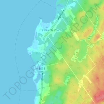
Name: Church Point topographic map, elevation, terrain.
Average elevation: 16 m
Minimum elevation: -4 m
Maximum elevation: 65 m
Other topographic maps
Click on a map to view its topography, its elevation and its terrain.
Sandy Cove
Canada > Nova Scotia > Digby County
Sandy Cove, Digby Municipal District, Digby County, Nova Scotia, B0V 1E0, Canada
Average elevation: 28 m
Ashmore
Canada > Nova Scotia > Digby County > Ashmore
Ashmore, Digby Municipal District, Digby County, Nova Scotia, B0W 3T0, Canada
Average elevation: 35 m
East Ferry
Canada > Nova Scotia > Digby County
East Ferry, Digby Municipal District, Digby County, Nova Scotia, B0V 1E0, Canada
Average elevation: 22 m
Digby
Canada > Nova Scotia > Digby County > Town of Digby
Digby, Town of Digby, Digby County, Nova Scotia, B0V 1A0, Canada
Average elevation: 16 m
Woodvale
Canada > Nova Scotia > Digby County
Woodvale, Clare Municipal District, Digby County, Nova Scotia, Canada
Average elevation: 13 m