Geolocate

Guruvayur topographic map

Click on the map to display elevation.

About this map

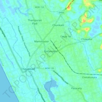
Name: Guruvayur topographic map, elevation, terrain.

Location: Guruvayur, Chavakkad, Thrissur District, Kerala, 680101, India (10.55504 76.00179 10.63504 76.08179)

Average elevation: 6 m

Minimum elevation: -4 m

Maximum elevation: 32 m

Other topographic maps

Click on a map to view its topography, its elevation and its terrain.

Triprayar Beach

India > Kerala > Chavakkad > Thriprayar

Average elevation: 4 m

Nattika

India > Kerala > Chavakkad > Cherkara

Average elevation: 5 m

Guruvayoor

India > Kerala > Chavakkad > Engandiyur

Average elevation: 5 m

Poonchira

India > Kerala > Chavakkad

Average elevation: 8 m

Gear up for your next adventure:

🛰️Outdoor GPS Navigation - Navigation devices for remote and off-grid areas
📕Outdoor Navigation Books - Learn traditional and modern navigation techniques
🧵Survival Paracord - Multi-purpose cordage for emergency repairs and shelters
🗺️Scratch-off Peak Maps - Track your progress climbing Munros or Wainwrights
🧣Neck Gaiters - Versatile protection against wind and cold

As an Amazon Associate, this site earns from qualifying purchases at no extra cost to you.