
Marbach am Neckar topographic map
Interactive map
Click on the map to display elevation.
About this map
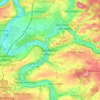
Name: Marbach am Neckar topographic map, elevation, terrain.
Average elevation: 251 m
Minimum elevation: 179 m
Maximum elevation: 355 m
The city (Stadt) of Marbach am Neckar covers 18.06 square kilometers (6.97 sq mi) of the district of Ludwigsburg in a total of four separate exclaves. Marbach is, according to government urban planning, part of the Stuttgart Metropolitan Region. Marbach's municipal areas are physically located in the basin of the Neckar, with the exception of its easternmost exclave, which lies in the Swabian-Franconian Forest. The lowest elevation above sea level in the municipal area, 190 meters (620 ft) Normalnull (NN), is found where the Neckar flows out of Marbach and into Benningen am Neckar. The highest elevation, 355 meters (1,165 ft), is found in the east, at the top of the Bülzberg.