
Langenhoe topographic map
Interactive map
Click on the map to display elevation.
About this map
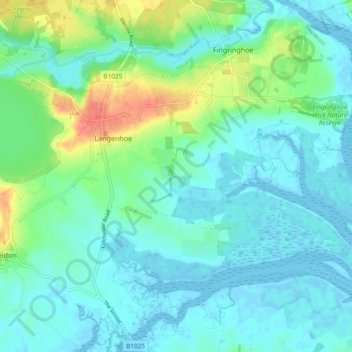
Name: Langenhoe topographic map, elevation, terrain.
Location: Langenhoe, Colchester, Essex, England, United Kingdom (51.80414 0.91053 51.84604 1.00386)
Average elevation: 11 m
Minimum elevation: -2 m
Maximum elevation: 45 m
Other topographic maps
Click on a map to view its topography, its elevation and its terrain.
Great Tey
United Kingdom > England > Colchester
Great Tey, Colchester, Essex, England, United Kingdom
Average elevation: 51 m
Copford
United Kingdom > England > Colchester
Copford, Colchester, Essex, England, United Kingdom
Average elevation: 36 m
Wakes Colne
United Kingdom > England > Colchester
Wakes Colne, Colchester, Essex, England, United Kingdom
Average elevation: 54 m
Tiptree
United Kingdom > England > Colchester
Tiptree, Colchester, Essex, England, United Kingdom
Average elevation: 53 m
Wivenhoe
United Kingdom > England > Colchester
Wivenhoe, Colchester, Essex, England, United Kingdom
Average elevation: 22 m
Layer Marney
United Kingdom > England > Colchester
Layer Marney, Colchester, Essex, England, United Kingdom
Average elevation: 39 m
East Mersea
United Kingdom > England > Colchester
East Mersea, Colchester, Essex, England, United Kingdom
Average elevation: 3 m