
Porto Alegre topographic map
Interactive map
Click on the map to display elevation.
About this map
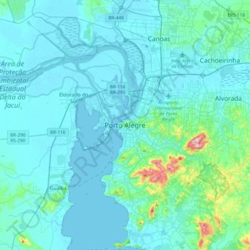
Name: Porto Alegre topographic map, elevation, terrain.
Average elevation: 27 m
Minimum elevation: -1 m
Maximum elevation: 308 m
Porto Alegre has a long coastline on the Guaíba Lake, and its topography is punctuated by 40 hills. In the lake, a vast body of water, a maze of islands facing the city creates an archipelago where a unique ecosystem gives shelter to abundant wildlife. The city area concentrates 28% of the native flora of Rio Grande do Sul, with 9,288 species. Among these, there are many trees which are vestiges of the Atlantic Forest. Fauna are also diversified, especially in the islands and hills. The Portoalegrense environs include many parks, squares and wooded streets.
Other topographic maps
Click on a map to view its topography, its elevation and its terrain.
Boa Vista
Brazil > Rio Grande do Sul > Metropolitan Region of Porto Alegre > Porto Alegre
Boa Vista, Porto Alegre, Região Geográfica Imediata de Porto Alegre, Metropolitan Region of Porto Alegre, Região Geográfica Intermediária de Porto Alegre, Rio Grande do Sul, South Region, Brazil
Average elevation: 47 m