
Up Holland topographic map
Interactive map
Click on the map to display elevation.
About this map
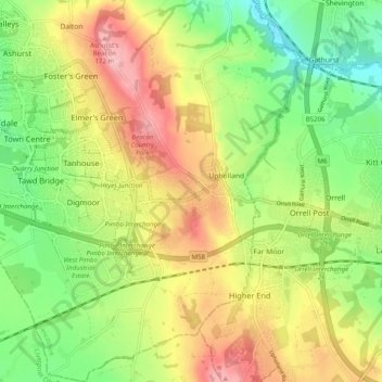
Name: Up Holland topographic map, elevation, terrain.
Average elevation: 89 m
Minimum elevation: 16 m
Maximum elevation: 179 m
Other topographic maps
Click on a map to view its topography, its elevation and its terrain.
Tontine
United Kingdom > England > Lancashire > West Lancashire > Upholland > Tontine
Tontine, Up Holland, Upholland, West Lancashire, Lancashire, North West England, England, WN5 8UJ, United Kingdom
Average elevation: 101 m