
Carlton topographic map
Interactive map
Click on the map to display elevation.
About this map
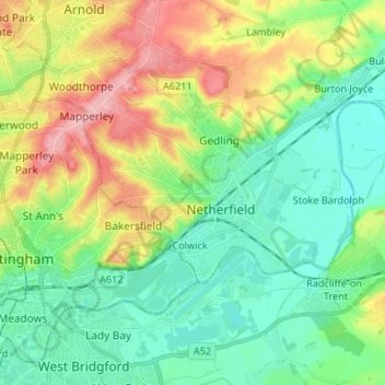
Name: Carlton topographic map, elevation, terrain.
Average elevation: 51 m
Minimum elevation: 11 m
Maximum elevation: 130 m
Other topographic maps
Click on a map to view its topography, its elevation and its terrain.
Lambley Lane Recreation Ground (North)
United Kingdom > England > Nottinghamshire > Gedling > Carlton
Lambley Lane Recreation Ground (North), Gedling, Carlton, Gedling, Nottinghamshire, England, United Kingdom
Average elevation: 73 m
Colwick Country Park
United Kingdom > England > Nottinghamshire > Gedling > Carlton > Colwick
Colwick Country Park, Colwick, Carlton, Gedling, Nottinghamshire, England, NG4 2EW, United Kingdom
Average elevation: 32 m