
Olso Lake topographic map
Interactive map
Click on the map to display elevation.
About this map
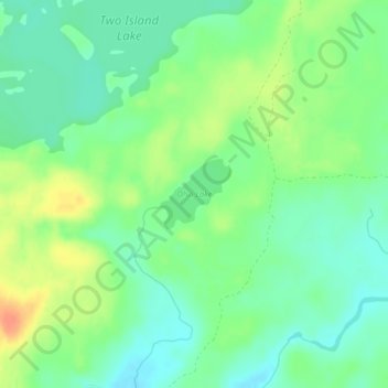
Name: Olso Lake topographic map, elevation, terrain.
Location: Olso Lake, West Cook, Cook County, Minnesota, United States (47.85966 -90.46020 47.86455 -90.45282)
Average elevation: 544 m
Minimum elevation: 528 m
Maximum elevation: 569 m
Other topographic maps
Click on a map to view its topography, its elevation and its terrain.
Eagle Mountain
United States > Minnesota > Cook County
Eagle Mountain is only about 15 miles (24 km) from Minnesota's lowest elevation, Lake Superior, at 600 feet (183 m). It is part of the Canadian Shield. Confusingly, there is another much shorter peak also named Eagle Mountain in northern Minnesota. The shorter peak is part of the Lutsen Mountains ski resort.
Average elevation: 596 m
Eagle Mountain
United States > Minnesota > Cook County
Eagle Mountain is only about 12 miles (19 km) from Minnesota's lowest elevation, Lake Superior, at 600 feet (183 m). It is part of the Canadian Shield. There is also another much shorter peak also named Eagle Mountain in northern Minnesota. The shorter peak is part of the Lutsen Mountains ski resort.
Average elevation: 596 m