
Na Hang District topographic map
Interactive map
Click on the map to display elevation.
About this map
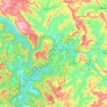
Name: Na Hang District topographic map, elevation, terrain.
Location: Na Hang District, Tuyen Quang Province, Vietnam (22.25533 105.25890 22.64079 105.59831)
Average elevation: 493 m
Minimum elevation: 42 m
Maximum elevation: 1,443 m
Other topographic maps
Click on a map to view its topography, its elevation and its terrain.
Tuyen Quang
Vietnam > Tuyen Quang Province
Tuyen Quang, Tuyen Quang Province, Vietnam
Average elevation: 88 m
Tuyen Quang
Vietnam > Tuyen Quang Province > Tuyen Quang > Tuyen Quang
Tuyen Quang, Tuyen Quang Province, Vietnam
Average elevation: 125 m