
Tuyen Quang topographic map
Interactive map
Click on the map to display elevation.
About this map
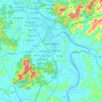
Name: Tuyen Quang topographic map, elevation, terrain.
Location: Tuyen Quang, Tuyen Quang Province, Vietnam (21.68341 105.09278 21.86602 105.29334)
Average elevation: 88 m
Minimum elevation: 15 m
Maximum elevation: 522 m
Other topographic maps
Click on a map to view its topography, its elevation and its terrain.
Na Hang District
Vietnam > Tuyen Quang Province
Na Hang District, Tuyen Quang Province, Vietnam
Average elevation: 493 m
Tuyen Quang
Vietnam > Tuyen Quang Province > Tuyen Quang > Tuyen Quang
Tuyen Quang, Tuyen Quang Province, Vietnam
Average elevation: 125 m