
San Narciso topographic map
Interactive map
Click on the map to display elevation.
About this map
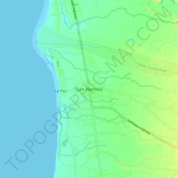
Name: San Narciso topographic map, elevation, terrain.
Location: San Narciso, Zambales, Central Luzon, 2205, Philippines (14.97552 120.03937 15.05552 120.11937)
Average elevation: 11 m
Minimum elevation: 0 m
Maximum elevation: 43 m
San Narciso is located in a relatively flat plain. West of the town is the South China Sea and to the east is bordered by the Sto. Tomas river are the Zambales Mountain Ranges. Average elevation is 3.6 metres (12 ft) above sea level and the highest elevation is 800 metres (2,600 ft) above sea level.