
Kingston upon Hull topographic map
Interactive map
Click on the map to display elevation.
About this map
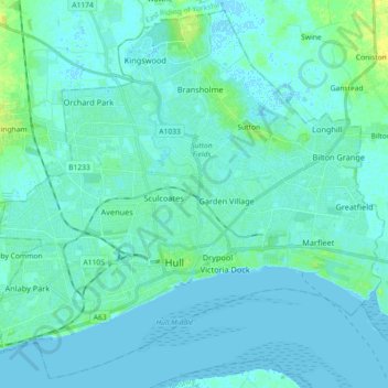
Name: Kingston upon Hull topographic map, elevation, terrain.
Location: Kingston upon Hull, England, United Kingdom (53.71156 -0.42258 53.81325 -0.24140)
Average elevation: 3 m
Minimum elevation: -2 m
Maximum elevation: 17 m
Kingston upon Hull is on the northern bank of the Humber Estuary. The city centre is west of the River Hull and close to the Humber. The city is built upon alluvial and glacial deposits which overlie chalk rocks but the underlying chalk has no influence on the topography. The land within the city is generally very flat and is only 2 to 4 metres (6.5 to 13 ft) above sea level. Because of the relative flatness of the site there are few physical constraints upon building and many open areas are the subject of pressures to build.
Other topographic maps
Click on a map to view its topography, its elevation and its terrain.
London
United Kingdom > England > London
London, Greater London, England, SW1A 2DX, United Kingdom
Average elevation: 42 m
London
London, Greater London, England, United Kingdom
Average elevation: 66 m
Bristol
United Kingdom > England > City of Bristol
Bristol, City of Bristol, West of England, England, United Kingdom
Average elevation: 55 m
Liverpool
Liverpool, Liverpool City Region, England, United Kingdom
Average elevation: 26 m
Birmingham
Birmingham, West Midlands Combined Authority, England, United Kingdom
Average elevation: 138 m
St Albans
United Kingdom > England > Hertfordshire > St Albans
St Albans, Hertfordshire, East of England, England, United Kingdom
Average elevation: 100 m
Sheffield
Sheffield, South Yorkshire, England, United Kingdom
Average elevation: 168 m
Nottingham
United Kingdom > England > Nottinghamshire
Nottingham, England, United Kingdom
Average elevation: 56 m
Oxford
United Kingdom > England > Oxfordshire
Oxford, Oxfordshire, England, United Kingdom
Average elevation: 81 m
South East England
South East England, England, United Kingdom
Average elevation: 69 m
Somerset
Somerset, South West England, England, United Kingdom
Average elevation: 87 m
Leighton Buzzard
United Kingdom > England > Central Bedfordshire
Leighton Buzzard, Central Bedfordshire, England, LU7 1EE, United Kingdom
Average elevation: 103 m
Coventry
Coventry, West Midlands Combined Authority, England, United Kingdom
Average elevation: 99 m
Sutton Coldfield
United Kingdom > England > Birmingham
Sutton Coldfield, Birmingham, West Midlands Combined Authority, England, United Kingdom
Average elevation: 124 m
Greater London
Greater London, England, United Kingdom
Average elevation: 66 m
Cambridge
United Kingdom > England > Cambridge
Cambridge, Cambridgeshire, East of England, England, United Kingdom
Average elevation: 18 m
Hull
United Kingdom > England > Kingston upon Hull
Hull, Kingston upon Hull, England, HU1 3RJ, United Kingdom
Average elevation: 21 m
Lincolnshire
Lincolnshire, East Midlands, England, United Kingdom
Average elevation: 28 m
Greater Manchester
Greater Manchester, England, United Kingdom
Average elevation: 141 m
Leasowe Lighthouse
United Kingdom > England > Moreton
Leasowe Lighthouse, Lingham Lane, Moreton, Wirral, Liverpool City Region, England, CH46 4TB, United Kingdom
Average elevation: 4 m
Lancaster
United Kingdom > England > Lancashire
Lancaster, Lancashire, England, United Kingdom
Average elevation: 84 m
Leeds
United Kingdom > England > Leeds
Leeds, Yorkshire and the Humber, England, LS1 6AL, United Kingdom
Average elevation: 94 m
Wimbledon
Wimbledon, Greater London, England, SW19 7NL, United Kingdom
Average elevation: 26 m
Wirral
Wirral, Liverpool City Region, England, United Kingdom
Average elevation: 21 m
City of London
United Kingdom > England > City of London > City of London
City of London, England, EC2V 5AE, United Kingdom
Average elevation: 42 m
Macclesfield
United Kingdom > England > Macclesfield
Macclesfield, Cheshire East, North West England, England, SK10 1EA, United Kingdom
Average elevation: 189 m
Maidenhead
United Kingdom > England > Royal Borough of Windsor and Maidenhead
Maidenhead, Royal Borough of Windsor and Maidenhead, England, SL6 1QB, United Kingdom
Average elevation: 41 m
Newcastle upon Tyne
Newcastle upon Tyne, North of Tyne, England, United Kingdom
Average elevation: 57 m
Knayton
United Kingdom > England > North Yorkshire
Knayton, North Yorkshire, England, YO7 4AY, United Kingdom
Average elevation: 76 m
Bagby
United Kingdom > England > North Yorkshire
Bagby, North Yorkshire, England, United Kingdom
Average elevation: 48 m
North West England
North West England, England, United Kingdom
Average elevation: 118 m
East Riding of Yorkshire
East Riding of Yorkshire, England, United Kingdom
Average elevation: 30 m
Harrogate
United Kingdom > England > North Yorkshire
Harrogate, North Yorkshire, England, United Kingdom
Average elevation: 131 m
Carlisle
United Kingdom > England > Cumberland
Carlisle, Cumberland, England, United Kingdom
Average elevation: 31 m
Gloucestershire
Gloucestershire, England, United Kingdom
Average elevation: 99 m
Warminster
United Kingdom > England > Wiltshire
Warminster, Wiltshire, England, United Kingdom
Average elevation: 143 m
North Yorkshire
North Yorkshire, Yorkshire and the Humber, England, United Kingdom
Average elevation: 153 m
Portishead
United Kingdom > England > Portishead
Portishead, North Somerset, South West England, England, BS20, United Kingdom
Average elevation: 26 m