
Delamere topographic map
Interactive map
Click on the map to display elevation.
About this map
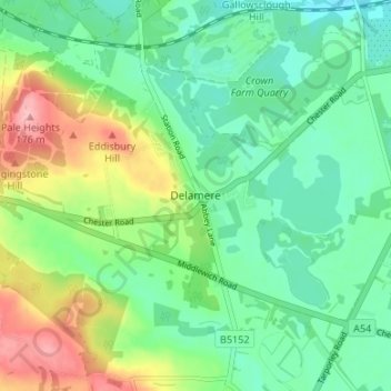
Name: Delamere topographic map, elevation, terrain.
Average elevation: 95 m
Minimum elevation: 56 m
Maximum elevation: 177 m
Other topographic maps
Click on a map to view its topography, its elevation and its terrain.
Eddisbury Hill Fort
United Kingdom > England > Cheshire West and Chester > Delamere
Eddisbury Hill Fort, Eddisbury Hill, Delamere and Oakmere, Delamere, Cheshire West and Chester, North West England, England, CW6 0SX, United Kingdom
Average elevation: 103 m