
Bracebridge topographic map
Interactive map
Click on the map to display elevation.
About this map
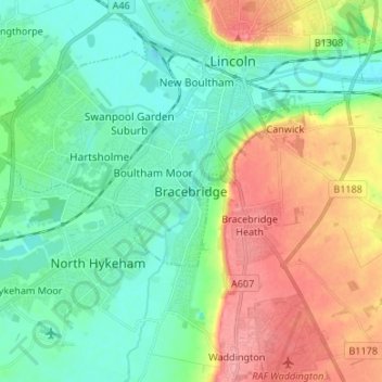
Name: Bracebridge topographic map, elevation, terrain.
Average elevation: 28 m
Minimum elevation: -1 m
Maximum elevation: 81 m
Other topographic maps
Click on a map to view its topography, its elevation and its terrain.
Lincoln Castle
United Kingdom > England > Lincolnshire > Lincoln
Lincoln Castle, West Gate Bridge, Whitton Park, New Boultham, Lincoln, Lincolnshire, England, LN1 3BJ, United Kingdom
Average elevation: 32 m
Steep Hill
United Kingdom > England > Lincolnshire > Lincoln
Steep Hill, Lincoln, Lincolnshire, England, LN1 3AA, United Kingdom
Average elevation: 32 m
Skellingthorpe Moor Plantation
United Kingdom > England > Lincolnshire > Lincoln
Skellingthorpe Moor Plantation, Birchwood, Lincoln, Lincolnshire, England, United Kingdom
Average elevation: 17 m
Brayford Pool
United Kingdom > England > Lincolnshire > Lincoln > Bracebridge
Brayford Pool, New Boultham, Bracebridge, Lincoln, Lincolnshire, England, United Kingdom
Average elevation: 20 m