
Make a donation
Gear up for your next adventure:
As an Amazon Associate, this site earns from qualifying purchases at no extra cost to you.
Dankuni topographic map
Click on the map to display elevation.
Make a donation
Gear up for your next adventure:
As an Amazon Associate, this site earns from qualifying purchases at no extra cost to you.
Dankuni
Located at an elevation of None meters (0 feet) above sea level, city's yearly temperature is 30.28°C (86.5°F) and it is 4.31% higher than India's averages. Dankuni typically receives about 150.21 millimeters (5.91 inches) of precipitation and has 150.54 rainy days (41.24% of the time) annually.
Make a donation
Gear up for your next adventure:
As an Amazon Associate, this site earns from qualifying purchases at no extra cost to you.
About this map
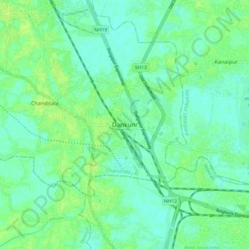
Name: Dankuni topographic map, elevation, terrain.
Location: Dankuni, Chanditala - II, Hooghly, West Bengal, 712311, India (22.64209 88.25074 22.72209 88.33074)
Average elevation: 6 m
Minimum elevation: 0 m
Maximum elevation: 11 m
Make a donation
Gear up for your next adventure:
As an Amazon Associate, this site earns from qualifying purchases at no extra cost to you.