
Wegberg topographic map
Interactive map
Click on the map to display elevation.
About this map
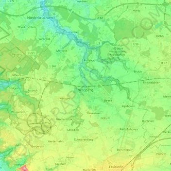
Name: Wegberg topographic map, elevation, terrain.
Location: Wegberg, Kreis Heinsberg, North Rhine-Westphalia, 41844, Germany (51.10114 6.13880 51.19019 6.35605)
Average elevation: 76 m
Minimum elevation: 39 m
Maximum elevation: 150 m
Other topographic maps
Click on a map to view its topography, its elevation and its terrain.
Auf dem Wengel
Germany > North Rhine-Westphalia > Kreis Heinsberg > Wegberg > Büch
Average elevation: 79 m
Hückelhoven
Germany > North Rhine-Westphalia > Kreis Heinsberg > Hückelhoven > Hückelhoven
Average elevation: 69 m